Agremo vs Climate FieldView
AI-enhanced independent comparison — features, pros, cons, pricing and rankings.
| Dimension | Agremo | Climate FieldView |
|---|---|---|
| Accuracy & Reliability | ||
| Ease of Use | ||
| Features & Capability | ||
| Value for Money | ||
| Performance & Speed | ||
| Popularity & Adoption |
Who each tool serves best — and when to pick the other one.
Agronomists, farmers, and agricultural consultants who rely on drone imagery for crop health and field variability analysis.
- You need detailed crop health analysis from drone or aerial imagery
- You want a cloud-based platform tailored for agricultural data insights
- Your team requires precise field variability reports for decision-making
Small-scale farmers or teams needing transparent pricing or extensive third-party integrations should consider alternatives.
- You need transparent, publicly available pricing for budgeting
- Free-tier limits are a blocker for your small-scale farming operations
- You require extensive API access or third-party integrations
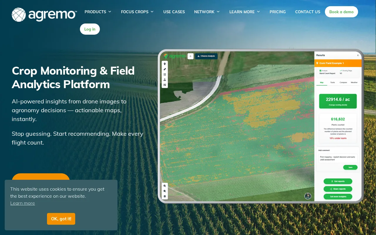
Ability to transform aerial imagery into actionable crop health insights with enterprise-grade analytics.
Growers and agronomists who need integrated real-time field data and analytics to optimize crop yields and management.
- You need real-time insights from multiple field data sources to improve crop decisions.
- You want to connect various agricultural equipment for seamless data integration.
- Your team requires detailed analytics linking field activities to harvest outcomes.
Small-scale farmers or users seeking free or low-cost solutions without extensive equipment integration needs.
- You need a free or freemium tool with no upfront costs or commitments.
- Free-tier limits are a blocker for your small-scale or hobby farming operations.
- You require open-source software or full API access for custom integrations.
The platform’s ability to connect multiple equipment sources and provide comprehensive field-to-harvest analytics.
| Feature | Agremo | Climate FieldView |
|---|---|---|
| Crop Health Monitoring | Analyzes aerial images to assess crop health status | Monitors crop health using collected field data |
Each tool's marketing-listed features. Where a feature appears under one tool but not the other, it usually reflects how the vendor describes their product — not a definitive capability gap.
- Yield Variability Analysis — Detects variability within fields to optimize management
- Cloud-Based Platform — Accessible via web with no local installation
- Multi-Crop Support — Supports analysis for various crop types
- Custom Reporting — Generates tailored reports for agronomists and farmers
- Equipment Connectivity — Connects with multiple farm equipment brands for data collection
- Field Data Visualization — Visualizes real-time field data for easy interpretation
- Multi-Layer Analytics — Analyzes data layers linking field activities to harvest results
- Harvest Outcome Reporting — Reports on yield and harvest performance
- Detailed aerial crop health analysis
- Cloud platform for easy access and scalability
- Designed specifically for agriculture professionals
- Provides actionable insights for crop management
- Supports multiple crop types and field conditions
- Extensive equipment connectivity
- Detailed field data analytics
- Links field activities to harvest outcomes
- Improves crop management decisions
- User-friendly interface
- No publicly available pricing information
- Lacks public API or integration options
- No free plan available
- Limited public pricing transparency
- No public API for custom integrations
- Precision crop health monitoring
- Field variability detection and mapping
- Agronomic decision support
- Drone imagery analysis for agriculture
- Yield optimization planning
- Real-time crop health monitoring
- Field data collection and visualization
- Equipment data integration
- Harvest outcome analysis
- Agronomic decision support
Natural languages each tool generates and understands. Primary languages are listed first.
What each tool can accept (input) and produce (output) — text, image, audio, video, code.
Pricing is available on request and tailored for enterprise customers; no public pricing tiers are listed.
—
Pricing details are not publicly disclosed; Climate FieldView offers paid plans tailored for growers and agronomists with no free tier.
-
Pro
popular
$20.00/mo -
Team
$30.00/mo
Regulatory frameworks each tool claims compliance with (HIPAA, SOC 2, GDPR, etc.).
How you can reach support — email, live chat, phone, community, docs.
- Email primary
- Documentation primary
How each tool is classified in the Volvenix catalog.
These vocabulary domains are managed in our catalog but not yet exposed at the tool level. We're tracking them for future expansion of this comparison.
- Encryption Types — AES-256, ChaCha20, RSA-2048, and similar at-rest/in-transit cipher families.
- Encryption Contexts — where encryption is applied (data at rest, in transit, end-to-end).
- Plan-tier Model Mapping — which AI models are available on which pricing tier (currently only the model list is tracked, not the per-plan availability).
- What is this tool?
- Agremo is a cloud platform that analyzes drone and aerial imagery to provide crop health and field variability insights.
- How much does it cost?
- Pricing is enterprise-based and available upon request; no public pricing is listed.
- Does it have a free plan?
- No, Agremo does not offer a free plan.
- What integrations does it support?
- Agremo does not publicly list integrations or API access.
- Who is it best for?
- It is best suited for farmers and agronomists needing detailed aerial crop health analysis.
- What is this tool?
- Climate FieldView is a platform that collects and analyzes field data to help growers optimize crop management.
- How much does it cost?
- Pricing is paid and tailored to users; exact costs are not publicly disclosed.
- Does it have a free plan?
- No, Climate FieldView does not offer a free plan.
- What integrations does it support?
- It supports connectivity with multiple agricultural equipment brands for seamless data integration.
- Who is it best for?
- It is best suited for growers and agronomists seeking detailed crop monitoring and data-driven management.
| Info | Agremo | Climate FieldView |
|---|---|---|
| Pricing | Enterprise | Paid |
| Category | Agriculture & AgTech AI | Agriculture & AgTech AI |
| Deployment | Cloud | Cloud |
| Learning Curve | Intermediate | Intermediate |
| Free Plan | ✗ | ✗ |
| AI Agent | ✓ | ✗ |
| Autonomy | Assistant | Copilot |
| Risk Tier | Low | Medium |
Agremo has an overall score of 4.9 out of 10 and offers enterprise-level pricing, typically targeting larger agricultural operations with advanced analytics and drone-based data collection. Climate FieldView scores slightly higher at 5.3 out of 10 and uses a paid pricing model, providing a digital platform focused on field data management and real-time monitoring for a broad range of farm sizes. While Agremo emphasizes aerial imagery and AI-driven insights, Climate FieldView centers on integrating multiple data sources to support decision-making in crop management.
ⓘ How Volvenix scores work
Scores are computed by Volvenix — not supplied by the vendors, and not third-party benchmark results. Each 0–10 dimension (Overall, Features, Usability, Support, Pricing) is a directional estimate aggregated from catalog signals — editorial cataloguing, content depth, engagement, and provider-reputation indicators — so treat them as a starting point, not a lab result.
Confidence reflects how complete the underlying data is for both tools; lower confidence means fewer signals were available, not a worse tool. We never accept payment for rankings or scores. More about how Volvenix works →